Road line - Section/Offset
Drawing|Geometry|Section/Offset
 This command calculates co-ordinates in the drawing or in a file for sections and offsets. It is also possible to calculate heights from the road profile and even from the road profile and the camber form. The last two commands are only available if you have the Longitudinal Section Module in Topocad.
To calculate the section/offset (heights/reduced by camber):
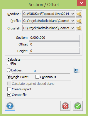
- Select Section/offset.
- Select the roadline by clicking the button ... You can also select a road profile (.TRP) and calculate the heights from the road profile in that section. It is also possible to load the camber form (.TCF) and reduce or add the heights from the road profile with the current camber in the section.
- Select whether you want to calculate the objects in a file or drawing or just a single point.
- Click OK.
- If you have selected objects from a file, the Open dialogue box will appear. Select the co-ordinates file you want to use to calculate the section/offset for the selected road line. Click OK.
- The result appears in a co-ordinates file. You can now edit and save it.
See also
Roadline for more information about the format of the roadline.
Surface check for a similar command using the comparison between the road geometry and measured points.