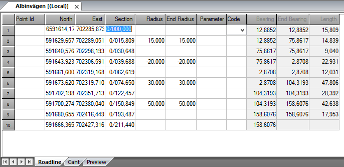
Roadline document
Roadline document (TRL)
In the road line document do you input the roadline. You can then import the road line to the drawing document to be calculated from.
Do like this to input a road line:
- Create a new Roadline document. Select New - Road line document (*.TRL).
- Input co-ordinates, eventual radius and parameters for clothoides.
- The road line is automatically generated and calculated.
- Save the road line.
- You can now import the road line to the document and use it for section, section/offset calculations.
Explanations to the document:
Point Id
Even called element when in Road line. Not important for the road line.
X- respectively Y- co-ordinates
The co-ordinates in plane where you have an element.
Section
The section number. If you leave it empty the software system will calculate the section for you. You can also give ”r;wrong”r; section number and this will take effect on all sections after this section. You can also use negative section values.
Radius
if it is a curve give the start radius here. Negative values for curves turning left.
End radius
End radius for this element if it is such. When using parameters it is important to type in the end radius.
Parameter
Enter the parameter for the clothoide. The parameter is always positive even if it is a left curve.
Code
Code for the tangent point.
Bearing
The bearing is calculated from other data.
End bearing
The end bearing is also calculated from other data.
Length
The length of the element is always calculated.
Export from road line
It is possible to export to other road line formats from the road line. The formats supported are:
- LIN Point road line format
- GVL Geosis road line format
Preview of road line
The tab shows current row in road line document marked by a circle in the preview. With possibilities to show all road line nodes.
