Roadline toolbox
Roadline|Roadline
This dialogue box is used to view different sections and offsets from the roadline. Select roadline in the scroll-down menu. If there is no current roadline open or available, click the Browse button to add your roadline.
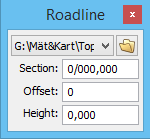
Tip: You can use this in conjuction with create point or create polyline tool. Just input section, offset and height from the selected roadline and press enter while you have the function create point or create polyline activated. You will then create the points in relation to the roadline.
Roadline current point
This toolbox is for roadline construction and displays:
- · The X- co-ordinate
- · The Y- co-ordinate
- · The section
- · Any radius the point may have.
- · The bearing from the point
To the right is a small column where you can mark and lock the specific field for this specific point.
When this toolbox is highlighted and a line is selected you will see the cross of the angle at every point in the line. These are the points which can be modified with this command. When the roadline is finished you need to select Save roadline.