Surface check
Drawing|Geometry|Check surface
The function is similar to the Section/Offset function except that it calculates the difference between measured and theoretical points and stores the result in a text file. The result can also be printed out.
The surface check can only be carried out if you have installed the Topocad Profile (Earthworks/design) section module.
To create a surface check:
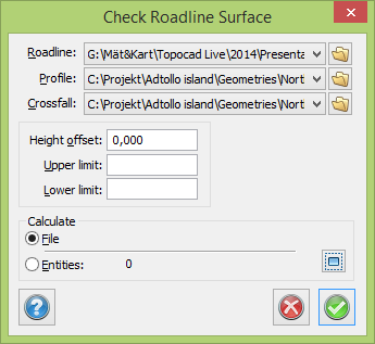
- Select the roadline and road profile and the camber form if applicable.
- If there is a height difference between the road profile and the measured level it can be defined here. For example, this would be the case if the road profile was created for the theoretical road but the measurement is carried out towards the terrace.
- Select the upper and lower limits if applicable.
- You can then choose to calculate the points from the file or from the drawing.
- Specify whether you want the results to be saved in a text file. Printout is the default setting.