Profile contents
Profile
|
Command |
Description |
|
|
|
|
|
|
|
|
|
|
|
|
|
|
|
|
|
|
|
|
|
|
|
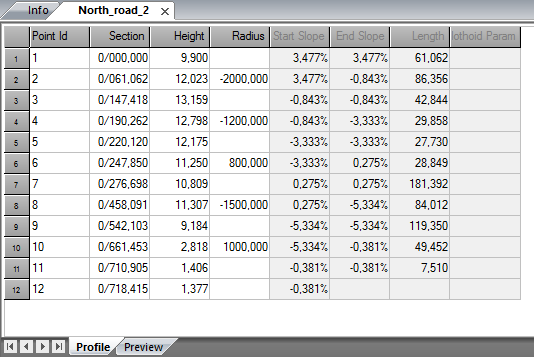
You enter the complete profile for your roadline in the road profile document (.trp).
It is used to place the sections at the correct height.
To enter a profile:
- Create a new profile document. Go to New and select Profile file (*.trp).
- Enter the element number, section, heights and any radius.
- The profile is automatically calculated. Note that it is possible to adjust the profile by going to Adjust.
- Save the profile under any name.
- It is now possible to use it for calculations.
Explanations for the document:
Point ID
This can be any number. It may also be called an Element no.
Section
The section. It is important that the section is correct compared to the one used in the appropriate roadline.
Height
Enter the height for the section.
Radius
Any radius for this point ID. A negative value for the radius means that the centre point is below the radius. Think of it this way - A sad face (radius) means a negative value and a happy face (radius) is a positive value.
Start slope
The start slope is calculated based on the data entered.
End slope
The end slope is calculated based on the data entered.
Length
The length of the element. This is always calculated based on the data entered.
You can enter an element (section, point ID) into a profile by rignt-cklick on grid and select Insert row. To delete a row, right-click and select Delete row(s).
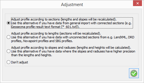
Adjust profile
The profile can be adjusted and possible errors can be corrected, however, the geometry will not be changed when adjusting.
Check profile
Control of profile gives a report regarding errors in bearing between different elements, if elements are too short or too long (discontinuity).
If there are no errors, you will get a message that says "No profile discontinuities found".
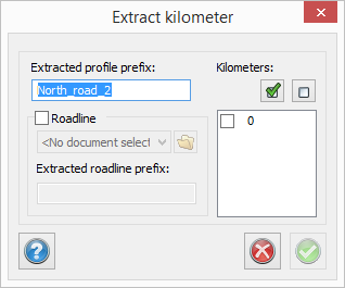
Extract kilometer
The profile is divided into every kilometer, with start before the kilometer and end after the kilometer, considering the length of the length table and also the first and the last element.
The command is also done in combination with the roadline, and the result will be a number of profiles and roadlines with name of kilometers.
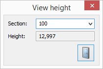
Height
Select section and view the height of this section.
Set/remove length table
The length table can be connected to the profile (if you have the railway module) which gives reports so the sections will follow this length table.
Settings/Nodes preview
You find the tab for preview of profile directly in the profile document. The current row in the profile document is marked with a circle in the preview.
There are settings for height scale and possibilities to show all profile nodes.