Advanced
Method
These settings control the calculation and take precedent over the settings made for each individual observation under the observation tab. The advantage of this is that you are sure that the selected type of calculation really applies to all observations. In order to use the individual settings for each individual observation, you must select Custom settings in this list.
Fixed adjustment, Local coordinate system
Does not use corrections for projection and ellipsoid.
Fixed adjustment, (coordinate system in document)
Use the settings made under in the document, from selecting Coordinate System.
If this is not Local, an ellipsoid correction will occur (height correction projection of length of the ellipsoid) and the projection correction for all observations.
To make your own coordinate system, go to System settings > Coordinate System > add a new Horizontal coordinate system. From there you can also point out a Geoid model, you can download these from ISG - International Service for the Geoid (polimi.it).
Unknown coordinate system (Free scale)
Uses a free scale to eliminate the affect of a scale error on the lengths. This method is ideal if you have major errors in the lengths and suspect that you have an incorrect Y-offset for the coordinates (affects the projection correction) or has a length gauge with a scale error. If an adjustment with free scale drastically reduces the length errors, you may assume that you have an error of this type.
Free adjustment, actual lengths
Release all points to ensure the error for the known coordinates does not affect the net. This is good for a local net that is to be as tension free as possible, or if you suspect that there is an error in the known coordinates. If this adjustment gives good results in a well-balanced net, this indicates that all observations are OK, and that an error in a normal (forced) adjustment depends on an error in the known coordinates. Remember that an observation in a traverse of observations that ends at a known point is calculated as a detail observation in free adjustment, which means that gross errors cannot be traced for observations of this type. In order for a free adjustment to be implemented successfully, the net should be designed as loops or triangles. Traverses without loops may produce uncertain results.
Projection and ellipsoid correction is deactivated for this adjustment. If you want to carry out a free adjustment with the corrections activated, you must use the speed setting Own settings instead; select Free adjustment under Detailed settings and then select Yes for all the corrections for the observations in the observation tab.
Free adjustment, projected lengths
This setting will apply the scale of the coordinatesystem to resize the lengths of the observations. Otherwise it is the same as regular free adjustment.
Free adjustment, local system
You restrict the known points here to two and allow the program to calculate a bearing from the station point, which retains its coordinates. This method also removes tension in the known points, but retains the station point coordinates (all known coordinates are affected in a totally free adjustment).
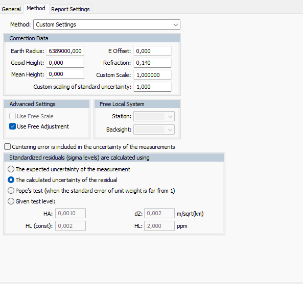
Custom Settings
Use the settings under the Observations tab exclusively, i.e. if the ellipsoid or projection correction is to be calculated for each observation.
Correction data
The values specified here are inactive (grey) if you have selected a speed setting option where the values have either been loaded from the project settings (File|Settings|Project Settings) or are not used in the calculation.
Earth radius-
required for correction calculations. As a standard value 6370000 is used for Sweden. If you use a RT90 coordinate system in the project settings and have specified the Use project settings speed setting, the program will calculate an earth radius as per the formulas in HMK Geodesi Stommätning (HMK Geodetics Control Point Surveying) Chap B.1.1 and data for Bessel's ellipsoid.
Geoid height-
the height (water surface) of the geoid compared to the map projection's reference ellipsoid (Bessel's ellipsoid applies to RT90). If you use a RT90 coordinate system in the project settings and have specified the Use project settings speed setting, the program will calculate a geoid height using the geoid height model RN92.
Y offset-
offset in Y which is often 1,500,000 for RT90 coordinates to avoid negative Y values. It is very important to check this value if you allow the net adjustment to calculate the projection correction. If you use coordinates with the specified offset, but forget to specify it as Y offset, a length of 100 m will have an error of around 2.7m. In File|Settings|Project settings|Coordinate you select a system with a specified offset. This is often abbreviated; e.g. RT90 5 GON V 60: -1 means that you subtract 6,000,000 from the X-coordinate and add 100,000 to the Y-coordinate. The projection correction formulas used are described in HMK Geodesi Stommätning Chap. C2.
Refraction-
the refraction of the light in the atmosphere. The standard value for the refraction coefficient is 0.140 for Swedish conditions. The refraction influences the calculation of the height difference and is used in calculations according to the definitions in HMK Geodesi Stommätning Chap. C3.
Mean height-
if you are to calculate the ellipsoid correction but do not have the z coordinates for your points (required in the calculation), you can specify the mean height above sea level for the net you want to calculate. For a length of 1,000m, a height error of 10m will result in a correction error of just 2mm, so you only need an approximate height for the points; meter accuracy is often enough. The height correction formulas are described in HMK Geodesi Stommätning Chap. C1.
Detailed settings: (active for the speed setting Open Settings)
Use free scale-
used if you want to calculate the scale if it is unknown, for searching of scale errors in nets with major improvements for lengths, or for tests of a net with known scale to see if the specified scale factor seems to tally.
Use free adjustment-
Use free adjustment- adjusts the net without taking fixed known coordinates into consideration. Good for nets that need to be free from tension. See Free adjustment under Netadj.|Settings Speed settings. As free adjustment here occurs under the Own settings speed setting, the ellipsoid and projection correction will be carried out for a certain observation if you have specified the observation's row in the survey data tab.
Use centring error for new points
If you have used forced centring consistently during the observations (had the tripod in the same place but changed the places of instruments and prisms) you will be aiming at the exact same point that you measured from. In practice, this means that the effects of the centring error will not influence the precision of the observations. The centring error is added to the mean error of the calculated new points instead. However, when you connect to a known point, the centring point will have an effect as the known coordinates apply to the point on the ground and not the position of the tripod over the point. The program will therefore include the centring error from known points in normal mode, but not new points when calculating the observation's apriori mean error. This is closest to reality if forced centrings dominate in the net. However, if you take the tripod down for the majority of the observations, you should also take the centring errors of the new points into consideration when calculating the apriori mean errors.
To sum up this means the following: If you have used forced centring predominantly in the net, the Use centring errors for new points box should NOT be checked; whereas is should be checked in reverse position.