Raster - Insert raster image from WMS
Create|Raster image from WMS
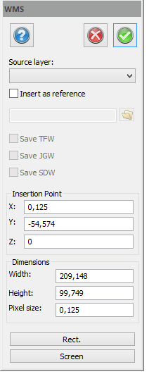 The command inserts an image from a WMS (Web Map Services) as a raster object in the drawing. The command requires at least one layer with WMS settings in the drawing. If the default settings are used, an image will be inserted to current view. It is also possible to select a rectangle from which the image shall be inserted.
If the image is inserted as reference, the image will be saved as a JPEG. You can also create a JGW-file which describes how the JPEG is georeffered. (It will automatically be saved in the right place if it is inserted in another drawing whith tje same co-ordinate system). The JGW file is saved at the same time as the drawing files is saved. If the image is not inserted as a reference, it will be a part of the drawing.
See also