Insert raster image
Drawing|Raster image
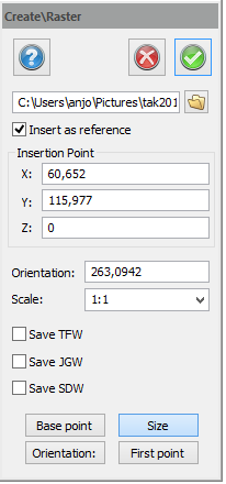 The command "Raster" adds a raster image to the drawing. The image can be inserted directly into the drawing or as a reference with a link to the image.
Settings that can be used are insertion coordinates in three dimensions; X, Y and Z, the direction of the image and the scale. If there is a Geo reference in the file or as an attached file, it will be read in the dialogue and applied.
Save TFW, JGW, SDW
Check boxes to save the geo ref. data in TFW, JGW and SDW files. The geo ref. data is saved the same time as the drawing is saved and has the same file name, except the file extension. If the geo ref. data is saved for a certain raster image, the raster image will get the same position if it is inserted into another drawing.
Click on selected point in drawing
If you click on the drawing and have a library of geo ref raster images, the software will automatically select the image covering the point you clicked on.
These images can be inserted in the drawing by clicking outside the frame of an image. When the cursor is placed inside of the frame, the frame will be drawn.
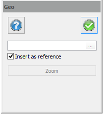
The Zoom button zooms the drawing so all of the images of the catalogue are covered.
If Insert as reference is checked, only the file name of the raster image will be stored in the drawing. If it is not checked, the whole image will be stored and the drawing file will be larger.
See also