Height Difference
Height difference
Drawing|Terrain|DTM Height difference
This function creates points, lines or Terrain documents to showcase differences between 2 Terrain surfaces.
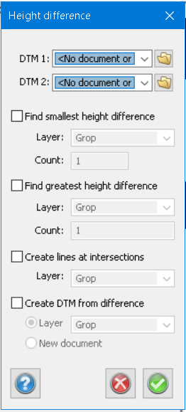
Find smallest height difference
Creates points on local minima. You get the points where the surfaces are closest to each other, decide how many points you want and the layer the points will be created in.
Find greatest height difference
Creates points on local maxima. You get the points where the surfaces are furthest apart in height to each other, decide how many points you want and the layer the points will be created in.
Create lines at intersections
Creates lines at intersections, decide what layer the lines will be created in.
Create DTM from difference
Will create a DTM where the height values are the delta height between DTM 1 and DTM 2.
Decide the layer you want the DTM and if you want it made in a new terrain file.