Heights from DTM or Point cloud
Drawing|Terrain|DTM Heights/Point cloud
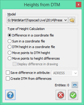
There are several ways to get the heights from a DTM or a Point cloud.
- Take the difference in heights of the selected object(s) in the DTM/Point cloud and save it to a co-ordinates file.
- Take the sum of the heights of the selected object(s) in the DTM/Point cloud and save it to a co-ordinates file.
- Take the heights of the selected objects from the DTM/Point cloud and save them to a co-ordinates file.
- Move points from the selected object(s) to the DTM/Point cloud .
- Move points to height differences.
You have to select the DTM/Point cloud to use before you begin. You can select an existing DTM/Point cloud by using the drop-down arrow or the Browse button.