Global options - general
Calculated sections|Global options - General
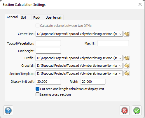
Centre-line/Roadline
A road line is required to create sections.
Removal of top soil / Max fill
This is where the thickness of the top soil removal is filled in. Max fill is the maximum depth at the road centre. If the maximum depth exceeds this value, the top soil will not be calculated for this section.
If the theoretical layer's outer point on one side is above ground, the removal of the soil on this side will start with maximum depth at the outer point of the terrace.
If the theoretical layer outer point on one side is below ground, the removal of the soil on this side will follow the terrace to the outer point on the theoretical layer, or until the terrace is under the chosen depth for soil removal. Afterwards the soil continues on chosen depth.
Profile
A profile is only needed if you are using a section template.
Section template
If you only are going to create terrain cross sections you do not have to use a section template.
The above dialogue also appears if anything is missing when you want to create the sections. If the data is all stored correctly, the following items will appear in a dialogue box.
Display limit left/Right
Set a limit on how far the cross sections shall be drawn. Leave blank to draw the entire cross section. This is a display mode and change no data.
Leaning cross section
The sections will follow the slope of the profile.