Calculate volume using slopes
Drawing|Terrain|DTM Slopes
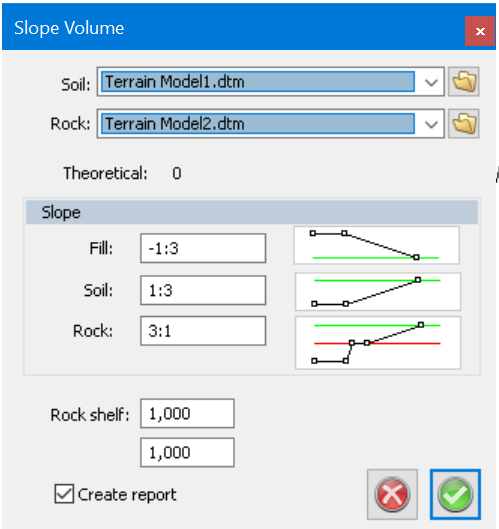
The function is used for volume calculation between theoretical and terrain models. The slope can be set for Fill, Soil and Rock, and also for the width of the Rock. It is also possible to set the width of the rock shelf.
The procedure is as follows:
- Open a terrain model for the soil layer. Also, open a model for the rock layer if needed.
- After that, create a new drawing. Draw the excavation surface as a closed polyline. Make sure the excavation surface is placed so it is covered by the terrain models. Also make sure the point's z coordinates are correct. The excavation surface doesn't have to be flat, the z coordinates can vary. Be aware of that it is not sure how the excavation surface will look in 3D if the z coordinates varies. Draw all of the excavation surfaces if several shall be used.
- Select all the excavation surfaces and select command DTM | Volume using slopes.
- Select soil model (and possible rock model) in the dialogue. Set the slopes for Fill, Soil and Rock. If a rock shelf shall be created - set the width, or the value 0. If no rock shelf is needed, the values for rock shelf and slope in Rock doesn't have to be set. Interval sets the accuracy in the volume calculation. Lower value gives higher precision but takes more time. The volume is calculated by splitting up the area in a grid, where all the squares's sides are equal and with a width the same as the Interval. The height difference is calculated for every square between theoretical and the terrain models. These values are summarized and multiplied with the area of the square to get the total volume.
- When all the values are set, click "OK". The software system will first create a DTM for the theoretical layer including the excavation surface and its slopes. Then the volumes are calculated and the result is shown in a window. The rock volume is the volume between the underside of the rock model and the theoretical. The soil model is the volume between the underside of the soil model and the theoretical minus the rock volume. The fill volume is the volume between the soil models upper side and the theoretical. The software system doesn't make a control if the drawn bottom excavation surfaces are "normal".