Import from Trimble
Drawing|Import|Trimble
It is possible to transfer data between a Spectra Precision instrument and Geodat, Geodimeter and the control unit (4000). All Geodimeter instruments from 400 and above are compatible. ACU is now also compatible.
To import a file:
- Open the document you want to import data into. To import survey data you will need to open a survey data document (SUR). To import co-ordinates you will need to open a drawing.
- Connect the field memory/station to the computer. Note that the serial port is male on the computer and can be 9 or 25 pin.
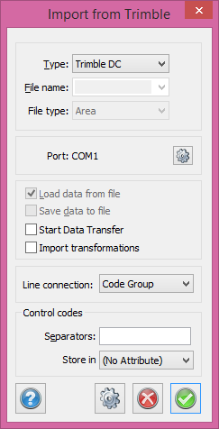
- Click File - Import - Trimble. In the upper field select the type of field memory to be used. This can be done automatically.
- Select the file(s) to be imported. A file list will be displayed.
- Click OK.
Line connections:
|
Label defined |
The label specifies the start and end of the line |
|
Line numbering 1 2, 3, 4, 6, 7, |
Intermittent: When the point ID jumps a step, the start of a new line will be created. |
|
Line numbering 1.01 1.02, 2.01, 2.02, 6, 7, |
The first number is the line ID. |
|
Control code |
The control code specifies the start and end of the line as well as other items. |
|
Code |
The same code will give the same line each time. |
Support for Zeiss M5 digital leveller.
Read more about point codes at Edit code table