Current Point
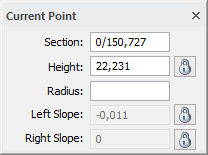
Shows the section, height, radius and slope for the current point. To the right is a column in which you can select and lock any of the above fields for the specific Point. This box is similar to the one used in Roadline - Current Point. This box is vital for editing the road profile.
Lock height: If lock height is selected the point's height cannot be changed in any way except by selecting a value in the dialogue, when the point is selected. If the height is unlocked it changes depending on how the user changes contiguous points.
Lock left slope / Lock right slope: Locks the slope on the right or left side of the point. Then the user can edit the value for the slope. A locked slope can only be changed by selecting a new value in the dialogue.
To unlock a height or a slope just click the checkbox.
The procedure is as follows:
- Go to Insert points.
- You can now click on the positions in the profile form at which you want to place your tangent points. Note that the tangent points are inserted even for a radius - the tangent point for any radius is in the fillet of the two slopes that are involved in the radius.
- The simplest method is to click on the approximate point where you want to place the points and then change the position in the "Current Point" toolbox. As soon as you input a radius at the point, it will be calculated and displayed. The new tangent points will be calculated with no bearing difference.
- When you are satisfied with your road profile go to Save profile. The road profile document is displayed and you can save the profile.