Calculate survey data
Survey|Calculate
Use this to calculate the survey when you have one or more stations with survey data.
Columns
Observation type: Transfer Point reading backwards and forwards
Detail: Read only forward, point not included in the train.
Distance: Distance to bar.
Reading: Read height on bar.
Measured height: Height were calculated by summing the height differences.
Residual: Indicates the improvement added to the measured height after calculation.
Calculated height: Adjusted height.
Pt. Status: Indicates whether the point (forward or reverse) is used as fix at the calculation.
Connection error: Connection error between known points.
Height diff: Differences between read forward and backward.
Length diff: The difference between the lengths forwards and backwards.
Length: The sum of the lengths forward and backward.
Origin: Name of the file that you imported from.
To calculate co-ordinates:
- Open the survey document with the data you want to use to calculate co-ordinates.
- Select Survey|Calculate from the menu.
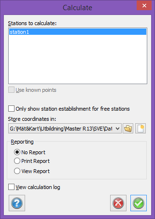
- The dialogue box that opens indicates how many stations there are in the survey. All of them are selected. If you want to exclude one or more of the stations from the calculation, select the ones that should be calculated. Use Ctrl to select one at a time or Shift to select several stations at once.
- If you want to study the station calculations click in the box in bottom left corner.
- Select the drawing in which you want the survey to be placed. You can select an open drawing, a previously saved drawing or a new drawing. If you select a new drawing it will be the default drawing that is selected (if there is one).
- Station establishment: Alternative for skipping station establishment for free stations. Checked box means the window for station establishment only will be viewed for free stations.
- Click Continue.
![]()
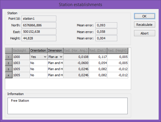
- The stations, including free stations, will appear one by one. See Free station for more information about free station calculation.
- If you clicked in the View box the calculation window will appear on the screen. Click Continue when you have finished, or Cancel if there are any errors.
- The co-ordinates will be placed in the drawing.
TIP! The calculation requires known points. These can be stored in the known points file (see Settings), on the co-ordinates tab in the survey document or as station co-ordinates on the Survey tab (this is where you are now).