Geodimeter label configuration
Drawing|Import|Trimble
It is easy to define labels 84-99 in the Spectra Precision instrument. In the Geodimeter this is called U.D.S. - User Defined System. The instructions below are for Topocad. To learn how to create definitions in the Geodimeter see the bottom of this screen. You will find further instructions in the Geodimeter reference manual or you can contact your local Geodimeter dealer.
To define a label:
1. Click the Config button.
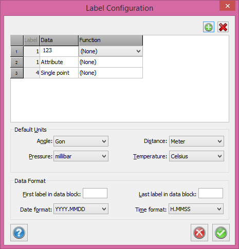
Some pre-defined label settings are listed. You can select from this list or delete them and add new ones.
Label settings
The pre-defined label settings are:
Start of line
End of line
Point
End of line + Start of line
Backsight (Rear of object)
Check point
Remark
Attribute type
Attribute (value)
Labels relating to the same type of observation should ideally be set up as the same label but with different data. For example Label 99 is used for line numbering: data 1 and -1 for Start of line, 2 and -2 for End of line, 3 and -3 for single point data and 4 and -4 for End of line and Start of new line at the same point. In practical measurements the instrument will request label 99 and you enter the data for 1, 2, 3 or 4.
The backsight and the check point can have the same label even when these functions do not appear at the same point. The backsight function can be used in free stations. If you do not want to measure all backsights at once, measure them when they are close to your normal survey point.
There is no need to enter a data value under Remark because text can be edited for this label.
Using U.D.S. in your Geodimeter:
In the Geodimeter the user can define the labels 84 to 99. First, set the instrument to On. Disconnect the double axle pendulum with function 22. (Function 22, [Ent], 0, [Ent]). To add a label press [PRG] [41] [Ent] (Create label). Select a label number between 84 and 99. Press [Ent]. If the display shows F99 it is free to use. You can now enter an alphabetic text by clicking the ASCII button and then entering the text. i.e. LINE = 78, 73, 78, 69. Press [Ent]. To finish press [Ent] again.
This tells the Geodimeter that you want to use your defined label. To create your own U.D.S. use [Prg] [40] and define all the labels that you want to use in the survey. See the Geodimeter manual for more information.